Corn Maze

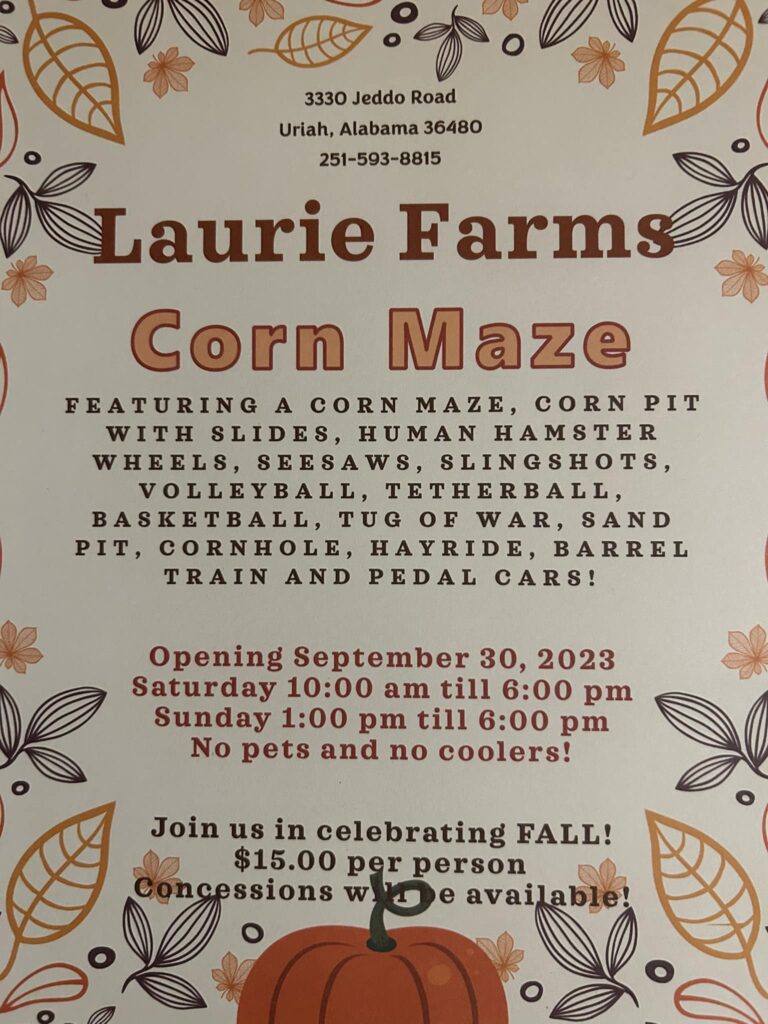
I hear it said on a daily basis, that there is nothing here for the kids to do. Well Laurie Farms has solved that dilemma for folks in this part of the world. For the next few weekends there is indeed something for them to do.

Laurie Farms will be hosting a Corn Maze and much more.

Starting September 30, and every Saturday from 10:00 AM till 6:00 PM, and every Sunday from 1:00 PM till 6:00 they will be open. There are also some spaces open for school field trips as well during the week.

As I ramble across this country, I run into some of all kinds of interesting things and people. I am forever amazed at the ingenuity of the people around us. It seems like around every turn there is something new and exciting to see and another encounter that is better than the last.

I see all kinds of things out there to look at and experience. Today I encountered something new and fresh for the area of Monroe County, Alabama. 

I drove down to below Uriah, Alabama and visited Laurie Farms. I had communicated with George Laurie concerning him putting on a Corn Maze this year. Immediately when he told me what he was planning I had to see for myself. As always nosey me had to know what, when, why, and how. 

I scheduled with George to be there this afternoon to get a grand tour. I was literally awestruck when I saw. I almost, could not, believe what I was looking at. I honestly do not know what I was expecting but I sure wasn’t expecting what I found. All I could say was WOW.

George told me when we talked earlier in the week that he was hosting a Corn Maze. I had heard of a Corn Maze before, but I thought of a Corn Maze as something that somebody had gone out in a cornfield and pulled up corn plants in a certain pattern or something. I had no clue even how you made such a thing.

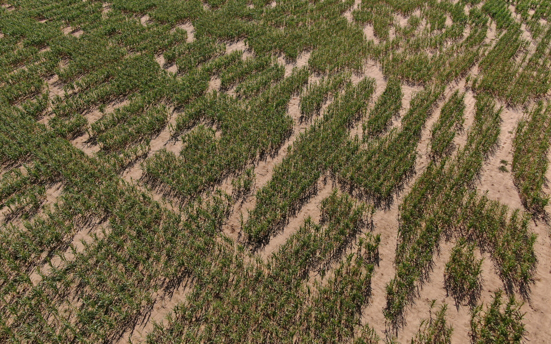
George explained to me that they had been able to get a precision planter that they found a corn maze somewhere and downloaded it and took it to a chemical company and they made a program and put it on an SD Card and then put that in the controller for the planter and it planted the seed where they needed to be planted to make the maze. They had to double plant so that the rows were at different angles.

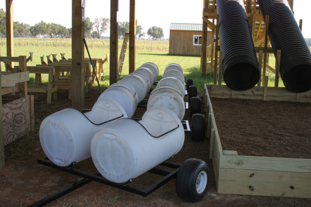
That alone intrigued me. But then we went on past the field and lo and behold I saw this incredible amount of different stuff out there. Most of it hand built, but with incredible workmanship. There are games and rides and so many things to do.

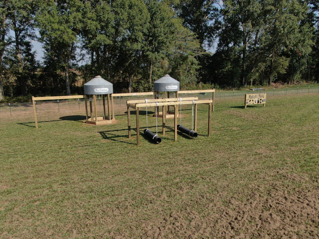
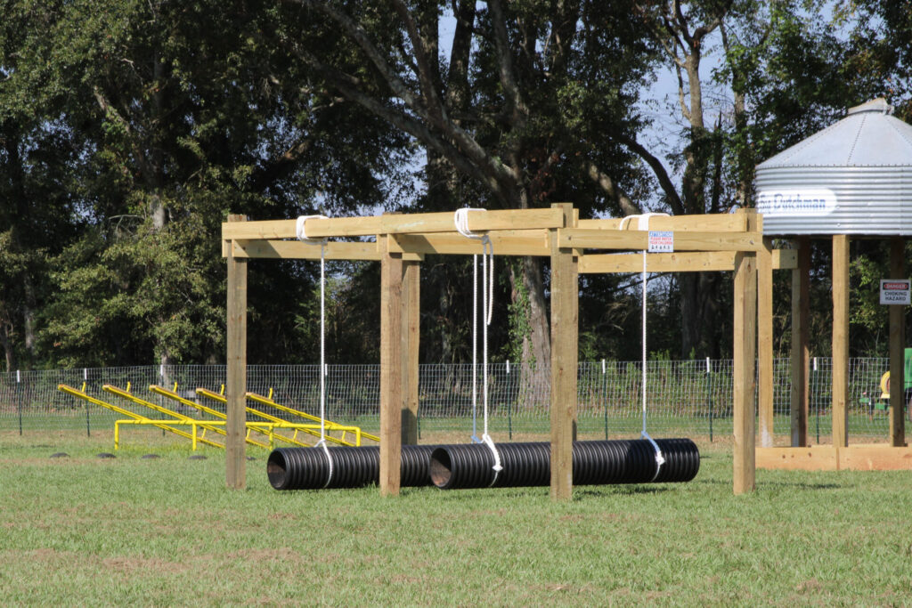
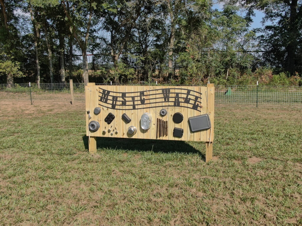
Under the shed there are these large tubes that will be a slide into a pit of shelled corn. There are these wooden sawhorses with a wooden cow head on them that the kids can throw a hula hoop over the head like a cowboy ropes a cow. There are these hand pumps with a white trough that travels a distance that will be a duck race.

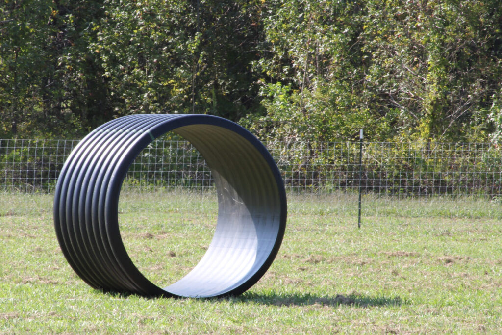
There are these large round tubes out there that are called Human Hamster Wheels. There are Tether Ball games. Tug of War Games and Basketball Throw games are there. There is a Barrell Train ride, and a Hayride.

There will be sodas, and hamburgers, and hotdogs, and sausage dogs.

There is a dozen or so picnic tables, but seating will be limited so folks will need to bring lawn chairs to sit in.

There will be no coolers allowed and there will be no pets allowed.

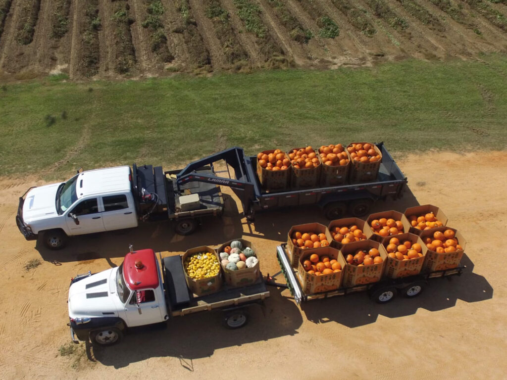
There are pallets of pumpkins for sale also of various sizes and colors.

DCIM100MEDIADJI_0149.JPG

There is a probably a whole lot more that I didn’t even pick up on and ask about.

I came down to see Laurie Farms Corn Maze expecting to just see a field of corn with a maze through it. I left shaking my head at how nice all the stuff they had looked. George said that they had been working on this project since last December. It is amazing how much stuff they have built and the quality of workmanship in the things they have.

All I can say is there is now something for your kids to do here for the next few weeks so do not hesitate to support these folks who have gone to great lengths to bring this to this area.

Laurie Farms

3331 Jeddo Road

Uriah, AL 36480

Rambling The Southland

As many of you know that follow me on Facebook, and other sources online and even in person, I travel a lot. In fact, I have made it my mission to visit all 67 counties in Alabama within the next year. Somewhere in that timeframe I intend to visit a lot more of Mississippi as well.

More than one person has asked me why, are you doing that?

Well, it goes like this. As many who know me know, I have a fascination for history. Now at different times I have interest in different things. Plus, I have an overwhelming interest in photography. Now, put the two together and guess what you come up with? I have an almost unquenchable interest in taking photographs of things from the past.

Living in Monroe County, Alabama I have seen the towns of Frisco City, Repton, Peterman, Tunnel Springs, Beatrice and so forth pretty much dry up in my lifetime. I mean there are still people there but there are basically just rows of rotting down buildings that are for the most part falling in. I guess it had never even dawned on me that this was a problem in other places. Not sure why, but it just never seemed to really click.

As many know I also fly drones and love old Fire Towers. A couple of years ago I started on a project to locate and do a drone video of as many of those old Fire Towers as I could find. I don’t know why but even with that I had no clue as to how many were standing still in the State of Alabama nor the condition, they were in.

New Hope Church Natchez AL.
Bull Slough Bridge
Coaling Tower

As I started to travel and get photos of those towers. I also started to notice how many old churches that there are standing that are abandoned or are on the verge of being abandoned. It was like a light bulb went off in my head I guess you could say. It is like most small towns you go into there is one or two old churches normally that were founded in the mid to late 1800’s that are just sitting there.

Then as I rode through the towns, I was familiar with and for some reason I started to really notice how many buildings were vacant and rotting down it really started to hit me. These are going away fast. The buildings, the churches, and the fire towers. They are all going away at an alarming rate. 

That is when my mission I guess you would call it became clear to me. I am retired. I have less and less responsibilities. I have my health. I have decent vehicles, and I have decent equipment to document this stuff with. I am not wealthy by any stretch of the imagination but by managing reasonably well I have the resources to travel and do it. 

Here is my Dodge Caravan that is converted into a sleeper van. It has AC and an almost full sized bed so that I can sleep comfortably. I also have a small cooler sized refrigerator. It is quite comfortable and is ideal for most excursions.

So that leads me to where I am now. I am on a mission to travel our beloved Southland and document as much of it as I can. Churches, fire towers, stores, water towers, other places of business and anything else interesting I see along the way.

As many know I am the founder and moderator of the group “The Good Ole Days of Monroe County Al.”.  I love that group. It is a great group, and it has done well. It however as was created is for Monroe County Alabama and thus I wanted it to remain that way.

I quickly realized that doing what I wanted to do was going to cause me to do a lot out of Monroe County. One visit to Mississippi made me realize that it was going to be more than just Alabama. Thus, Jackson’s Ramblings came into being. Then my slogan, “Rambling the Southland and Beyond.” Well, that seemed to get it going. Then when I hit on a slogan, immediately I thought Facebook group. So, I named the Facebook Group, “Rambling the Southland and Beyond.” That way anything documented would fit the category.

There have been many contributors who have a like desire of photographing old, unusual, and or interesting things, that have shared and continue to share on the group. I hope that as time goes on that those and more will continue to share. If you area reading this and are one of those you are greatly appreciated.

At the time of this writing the group has 2740 or so members and is growing many weeks at the rate of 50 to 100 a week. It was created in June of 2022. My only hope is to see the group grow to how ever big it can grow. Tens of thousands would be incredible.

I also love to write. As those who take time to read my writing can readily see I have a lacking in writing skills. I aways joke and say that they only thing that kept me from doing great in high school was elementary school. I am the first to admit that I have issues with grammar and punctuation. However, I like to feel like that I make up for that with desire and determination.

With all of that said, there is a wealth of places, buildings, and other things that are standing today that in a very few years will no longer be standing. For the years I have left, and I hope it is a lot, I intend to take photos of those things, document them as best I can, and write about them as time allows. 

It would be incredible to be able to fund the travel, and equipment, to do this in some way while doing it. I do not have a large enough audience for any business or group to pay me sponsorship. My viewership on my blog is too small for the ads associated with it to make me money, or at least for this time. I have not updated my Youtube channel in a while as well. It takes a lot of time and effort to keep it all up. Some weeks I drive 500 plus miles or more. Sometimes I spend a night in my van some place to keep from having to stay in a hotel or drive home. Then there are hundreds of photos to look at figure out where they were taken, organize them and then file. It is a labor of love but also almost a full time job.

Hopefully in the future this can change. I plan to try to write more blog posts as I travel and interact more that way. Hopefully I can go back to doing more videos as well.

Thanks, to all who have supported me in this endeavor, and I look forward to meeting others along the way who have like interests.

Come join me as I Ramble the Southland and Beyond.

Bull Slough Bridge

Many times in life we wake up in the morning with something on our minds and for whatever reason that thought just does not go away. On this particular morning that was me, and the thought was of all things the Bull Slough bridge in Conecuh County.

Now I had never been to that bridge that I remembered any way. I had heard of it however for years, and I had seen numerous pictures of it. I know that many people talked about putting canoes and kayaks in there and it is popular with many people for that reason. 

I had recently visited another bridge upstream from this one a while back called Cohassett bridge that has been long ago abandoned. Unfortunately, on that visit it was a rainy day and I was not able to send a drone up and get any photos with it and only a few pictures with my camera and they were not great.

On this morning after having my coffee I announced to my wife my intentions for the day and she said she would as she many times does ride with me. 

We had actually been to Brooklyn a couple of months back on one of our rambling sessions but that day I did not have the Sepulga River on my mind. Today however that was pretty much all that was on my mind.

I then messaged a friend of mine that I knew kayaked that river and told him I was going. His immediate response was that low water level and blue skies should be a great day for a visit. He also recommended that I also visit the landing at Bottle Creek landing as well which is down river from it. 

With that encouragement we loaded the location in the GPS and pulled out heading that way. We went across US 84 to Repton and south on Al 41 to Conecuh County Road 6 and headed on across US 31 at Castleberry and then on down that way to Brooklyn. At Brooklyn we turned left on Co. Rd 43 and then right on Co. Rd. 43 and proceeded up to Bull Slough Road. Bull Slough Road is a narrow winding paved road that brings one to this magnificent old bridge that crosses the Sepulga River.

We met one log truck on the way in and there were several loaded log trailers sitting out to the side close to the bridge. While we were there several vehicles crossed. It has a 3 ton weight limit on it so no log trucks are able to cross.

According to Bridge finder.com and other sources Bull Slough bridge was built in 1924 and rehabilitated in 1970. Bridge Finder calls it a Warren Through Truss design. Other sources call it a Pony Truss design. Regardless of the true name of the design it is an interesting truss bridge. For all I know that might be two different names for the same design.

All sources I found said that it was 252 feet long and the longest span was 152.9 ft. All sources I found said it is 14 ft. Wide. It is definitely a one lane bridge for sure.

We drove down the side road to the landing and observed the bridge from the river level and then went back up and parked at the west end and started photographing it and then sent the drone up and got some awesome shots of this beautiful old bridge.

As always I am fascinated with anything that is historical and for me anyway this old bridge did not disappoint. It is 98 years old. That is for me anyway incredible. Yes, it looks primitive. Yes, it is in the middle of nowhere. I stood however and pictured in my mind to start off with probably few cars were in that part of the world in that era in time. Probably for years there were many more horses and mules either ridden across or pulling carts, wagons, or buggies than there were cars. Then as years passed the numbers of cars and trucks would have started to increase and the numbers of horses and mules and wagons would have decreased. I pondered on when the wagons and mules and horses had trickled to a stop to only be used by motor driven vehicles.

So many questions, so many things to just ponder on. Then I wondered how long had it been since a horse or mule drawn vehicle had crossed. That led to wondering how many cars crossed it a day period now. Obviously, it is a well-traveled road even though it is narrow and winding and relatively rough. I know during the time we were visiting and looking there were several that crossed today.

I can only imagine that when this bridge was built it was a wonder to behold and a spectacle that folks came for miles to see. It would have opened up a lot of opportunities to cross into Brooklyn for those who lived across the river. Although times were hard in the 1920’s it would have presented opportunity for folks to travel to and fro and made live easier for many. 

This section of the Sepulga is a beautiful wild little river that would definitely be a place that would be interesting to many people. I highly recommend a visit to the river if you like to canoe or kayak. If you are a history nut like me I highly recommend you visit the bridge and get a look and possibly a few photos of history.

It was a beautiful laid-back day in Eastern Conecuh County, Alabama. We are a blessed people to be able to enjoy the beauty of this great land.

Monroeville Spur of the L&N

The more I wander and look at the things of our great Southland the more I realize that there are numerous different people out there that are historians on many things. Some know about and continually search for information on things like churches. For others it might be just a certain community, county, or region. The list goes on and on as to things that people know love and continually dig to find out more about.

One particular segment that rings a cord with many is railroads. For some it is railroads in general. For others it is a particular railroad line or even a particular line of a certain railroad.

Mainline and siding facing south

For many the rich history of the L&N Railroad seems to bring out some incredible facts and memories. One such line is the L&N Line that ran from Flomation, Alabama to Selma, Alabama.

Being born in the late 1950’s and having relatives in, and spending much time at Beatrice, Al. I formed a lot of interest in the L&N Railroad myself.

I remember so many times the train coming through and us watching it. One of the highlights of that was going down to the tunnel at Tunnel Springs on Sunday afternoons when the train was going south and watching it go through the tunnel.

One interesting aspect of this railroad as I look back today is the fact that there were three long spurs off of this railroad in our area. To our north there was a spur from the area of Nadawah that went all the way into Camden. Then further southward on the line was the spur that ran from Cordoroy over to Vredenburgh. Finally further southward was the spur that ran from Monroe Station into Monroeville. There might have been other shorter spurs as well but if there are I have not seen them nor been able to find them on a map.

I purposely listed them from north to south because the southernmost spur is the one I wanted to discuss in this posting.

First crossing of spur from main line South end.

The spur from Monroe Station into Monroeville was an interesting spur to me anyway, for numerous reasons. In the early 1970’s we had a pasture at Monroe Station it was leased from Mr. Fred Sheffield. As a young teenager, my friend and I walked down that spur on numerous occasions to get to the pasture. The track switched right at the gate to our pasture.

If memory serves me correctly there were two sidings there or more. There was also two different switches on the railroad so that the train could switch in from either direction. By doing that the train could also switch in from one direction, pull past where the two tracks joined to make one. Then the switch could be thrown and it could back out onto the main line from the opposite side and be turned around on the mainline.

That was an interesting aspect of this spur to me. The spur at Cordoroy did the same thing and the one at Nadawah did also. From my understanding it had to be done that way to be serviceable by both north and south bound trains.

Once leaving the mainline at Monroe Station the train passed shortly over an overpass that crossed over the dirt road that led from Drewery Road to Monroe Station. That over pass stands to this date. It is a very small opening through which the road passes. It is a tight squeeze for about anything bigger than a small truck. This road was later named Hornady Drive when the 911 address system was implemented. There is an intersection in that road actually adjoining the road where this overpass crosses and the road under the overpass is named Deer Creek Road. 

For many years it appears that there was nothing but woods and farmland that it traversed through from the main line until it got into Monroeville. In the early 1970’s Harrigan Lumber Company built a large sawmill that was on the railroad a little over halfway from the main line to Monroeville. Prior to this sawmill there was a saw mill out on Drewery Road in Monroeville. The railroad served that mill with a siding. That mill was closed in the mid to late 1960’s from the best understanding I can attain.

There was a siding that split off of the spur at Harrigan lumber and the railroad crossed what is now Hornady Drive just below the Harrigan Property and traveled a short distance parallel to that road and then crossed that road again where George Preyear Road intersects with it and paralleled it for a distance.

There was a siding that split off and went into the woodyard owned by Container Corp. There pulp wood trucks brought in short pulpwood and it was unloaded and stacked and then reloaded on to rail cars to be shipped to a paper mill south of Monroeville.

The spur line crossed Drewery Road just to the north of this woodyard and proceeded on towards town. It made a long arching circle on towards the location of the old Monroeville Stockyard. This stockyard closed sometime in the 1960’s as well.

The Highway 21 bypass was built around 1968. The railroad crossed it a short distance south of where Drewery Road crossed the bypass. There was a long siding or you might call it a short spur off that spurline that actually went in to the back side of the Arvin Industries factory that is now a business incubator building where businesses rent and do startups in to get established. There is also a truck driving school located there. The main spur crossed Drewery Rd again close to where the present Walker Street connects with Drewery Road and proceeded right behind the row of houses that sits along Drewery Road on one’s right heading in towards town.

It then crossed Ivey Street where the Monroeville Gin was located. Then crossing Hines Street. There were numerous places through this area along the railroad that could utilize it. The railroad crossed East Claiborne Street where the present Fire Station and Monroeville City Hall is located.

Finally it ended in the alley behind where Barnett and Jackson Hardware was located.  

The Mainline L&N Railroad was built in 1900. This spur appears to have been built at the same time. It served till the mid 1960’s all the way into town. After that it slowly started to fade away as the track was removed into town in short increments. When the wood yard on Drewery Road closed that was one of the final businesses bringing it in as far as Drewery Road. It served Harrigan Lumber for several years longer. 

The track is still laid for quite some distance up. The bushes and other undergrowth is now head high in many places where the tracks are still in place at. I am sure that it is only a matter of time before it is all removed and there will be little to any remnants of anything left reminding those looking of the existence of this spur.

The closing of the particle board mill long known as the Temple Mill was the final nail in the coffin for the L&N Line. It had held on as track was taken up north from Beatrice and then southward to Tunnel Springs.

Monroeville suffered a great loss by losing this railroad and the spur in when it was shut down. Although it was not being utilized it still held the potential for rail service should it be needed.

One thought I always had was why there never was a spur in from the Frisco Railroad that passed just a little to the west of Monroeville. In fact the Frisco passed closer than the L&N to town and was a mainline railroad as well.

For over half a century the L&N Spur served Monroeville bringing in goods and taking products out. Like so many other small towns in the US. that once flourished Monroeville slowly changed course and finally started to dwindle in need for rail service as truck freight service increased. This closed this romantic time of rail service for what appears to be forever.

Tom Bevill Welcome Center

Tom Bevill Welcome Center

September is here and finally this long hot summer is winding down. We have seen some interesting things this year and are still looking forward to seeing more. There are a gazillion things out there to see, do and write about.

For the last year most of the travels I have had the opportunity to take were confined to the areas in and around Monroe County Al. and the counties surrounding it.

It was a welcome relief to me anyways to get to travel a further distance from home and ramble in different territories than I am familiar with.

We had been in the area of Pickensville Al. recently but basically made a flying trip through with very little time to ramble. On this trip we parked the motor home in the Pickensville Campground and were able to so some rambling.

We had seen the Tom Bevill Welcome center before from the outside but did not have time to visit. Today was a different story. It was just too inviting to pass up. 

We arrived a few minutes before opening time and so we rode down the road and walked the steps down to the river below the lock and dam. Then after exploring some of the area there we went back up to the Welcome Center. As we were driving up we saw the attendant opening the gate and we were the first people in for the day.

The attendant was a very cordial and knowledgeable lady who gave us the tour. She explained to us that the Tom Bevill Welcome Center was named after a U.S. Congressman who represented Alabama from 1967 till 1997 and was very much instrumental in the legislation that helped pave the way for the constructing of the Tennessee Tombigbee Waterway.

The building appears to be an Antebellum Home. In essence we found out that it is actually a replica that was built in 1985. The building was built to depict the period of time between the 1830’s to the 1860’s. 

Those who designed the building took ideas from three different mansions. There are actually  pictures of all three hanging on the wall in the main living room as you walk into the center. They were the Kirkwood that is in Eutaw, Al which still stands about 40 miles south. The Waverly Mansion is the second and it stands in Columbus Mississippi about 30 miles North. The third is the Rosemont that is located in Green County, Al. about 53 miles south. 

The cupola on top was inspired by the Kirkwood. The balcony on the front was inspired by the Waverly. The window design and the columns on the front were inspired by the Rosemont.

The foyer, main stairs and the lobby all have reproduction gas light chandeliers. Common to those fixtures was a cloth sleeve that covered the gas supply lines that supplied them. It was interesting to note that gas was used for lighting before electricity was available.

In one corner in the back of the main room stands a Grandfather clock. The clock still works but is not kept wound. This clock has a hand painted face that has seashell designs on it. The clock is an 1835 English antique. The case of the clock is made from a combination of mahogany and English oak.

There are various other pieces of antique furniture and mirrors scattered throughout the house. One of the mirrors that was intriguing to me was a mirror called Girandole mirror, or chaperone mirror. The reason it was called a chaperone mirror is it is of a convex type that makes the entire room visible in form one vantage point. I thought that was a very interesting mirror indeed.

The beautiful marble floors were made from black and white squares. The Black squares were imported from Europe and the white squares were from northern Alabama.

The landings of all of the stairways are heart pine that was salvaged from an 1830’s plantation house located near Uniontown, Al. The wood on the steps is also heart pine that was salvaged from other sources.

One interesting thig that I learned about these old mansions was that since there was no air conditioning the large open stair cases served a purpose other than just giving the ability to go from one floor to the next or serving as decoration. By opening the doors on the cupola on top and the front entrance doors the air would travel through the house up through the stairwells and create air movement that helped cool the entire house.

This is definitely a beautiful place to visit and the grounds are beautiful as well. One sad thing is that the cupola area is now inaccessible because of the fact that there is a safety issue. There are other places that need attention as well. Sadly like so many places that the U. S. Government owns and maintains funding has been held up to keep them properly maintained. 

I highly recommend that anybody that has the opportunity to visit this beautiful place come in and visit and learn. It is definitely a view of our beautiful historic southland.

Flomaton Coaling Tower

Now I don’t know about you but I am one who wants to know everything that there is to know about anything that I am presented with that is of interest.

I like fire towers, historic churches, historic anything basically. I like railroads, trains, and about any kind of equipment you can name as well. It doesn’t matter if it is running, siting on display or just in a picture. I guess I am just made that way.

Recently I saw a picture of the coaling tower at Flomaton, Al. that a friend of mine tagged me in on social media. According to the post it was going to be torn down. My friend asked me if I had any drone shots of it.

Click image to enlarge.

Oh, I forgot to say above I love drones also. I love to take photos with them and make videos with them and anything else that can be done with them.

Then he said they are going to tear it down next week. Now understand something. Up till that moment I did not even know that it existed. Also, I was not even certain what it was nor what it did. However, if it was something that big, and it stood at the railroad, I was interested.

Click photo to enlarge

I immediately started researching. What I found out was that this was a large concrete bin so to speak that they put coal into, and a steam engine would come underneath it and stop. Then when the coal car that was used to carry the coal to power the locomotive was in the right position a gate underneath the big concrete thing would open and coal would pour out into the coal car.

Also, as I researched I found that the proper name for this concrete thing was a Coaling Tower. I also learned that that normally where one was there was a source of water to fill the water tanks on the steam engine. You know coal makes heat; water heated makes steam. Gotta have water for steam and gotta have coal to heat the water. Then I read somewhere that normally there was a way to put sand on a locomotive also. Sand is put on the tracks so the wheels will grip. I knew that from watching trains as a kid. So they did all three normally at that one place.

Upon further reading I found that normally one of these “Coaling Towers” would be placed in a train yard or area where they serviced engines.

Now I found out what it was and all I had left to find out was where it was, when it was.

This particular one was built in 1943. It was in the train yard at Flomaton, Alabama. Flomaton Alabama is a small town located on the Alabama, Florida line. In fact, as you pass over the bridge that goes over the railroad at the other end of the rail yard from the coaling tower you cross into Florida.

Now with all of that information and hearing that this one was about to come down, I had to go see it. 

Driving up to it, for me anyway it was a sight to behold. I had never seen one of those. Big equipment, coal handling equipment, conveyors, and the like. I had seen this stuff, worked on this stuff, been there done that. 

Two things about this thing though jumped out at me. First off it was over the railroad. Did I say I was fascinated with railroads? If I did, I will say it again. I am fascinated with anything associated with railroads. Secondly It had engraved on the cement up high the numbers 1943 and it had L&N engraved on it. 

Now with that it had my full 100% attention. I had read much about the history of the L&N Railroad. I knew from my lifetime of living in Rural Southwest Alabama a lot about the L&N Railroad. I had on countless occasions witnessed the L&N Trains traveling the line from Flomaton to Selma back in the 1960’s and 70’s. I had actually been told one time that an old man I knew as a little kid worked on the construction of the L&N Tunnel at Tunnel Springs, Al.

Click image to enlarge.

Any way when I saw this thing, I knew that I had to take some drone pictures of it. So I found a place to park my Jeep and got my drone out and sent it up. Flew it into various positions and shot some photos of it. Now I have those photos some of which I am sharing with you in this article. I hope you enjoy them as much as I enjoyed taking them. 

If the information I have is correct, it is torn down now and there will never be any more photos taken of this beautiful old piece of American Railroad History. With that in mind I am thankful to have found out and get there before it was too late to take a few shots of it before it was gone. If that information is not true then you know about it now and you an go see it and take some pictures of it.

Davis Ferry

Davis Ferry is located in Monroe County Al,

It is a link across the Alabama River between Franklin, Al and Packers Bend.

Photo by Glenn Brooks
Origins of this photo unknown. I will gladly give credit to the owner.

It has been reported that there has been a ferry in this location off and on as far back as the 1830’s.

1970’s Ferry

This is the ferry that was put in at this location in the late 1960’s. It was moved to the Davis Ferry location from upriver at Holley Ferry after the Al Hwy 10 bridge was put in at Pine Hill a few miles upriver.

This ferry was powered by an inline six cylinder engine. The ferry had a paddle wheel that turned to propel the ferry. It was held in place and guided by a cable stretched high over the river. There were two cables one on each end of the ferry with rollers on he overhead cable.

The overhead cable is held taunt between two towers with a winch on the East Bank. During high water the cable could be lowered so that tug boats could pass over the cable if the river was too high for them to go under. The ferry would not be operational during the time the river was at flood stage.

Some years ago this cable was hit by a military helicopter during a training exercise.

Here is a filing at the Monroe County Public Library. It was submitted by J.C. Stabler a long time ferry operator several years ago.

Davis Ferry is located on the Alabama River at the Haines Island Park in Monroe County. The old ferry boat that is used at Davis Ferry has been around for a long time. It was moved from upriver at Holley Ferry in the early 1970’s when the Highway 10 bridge was completed and opened for operation. Years ago, there were several ferries like this one that operated along the Alabama River and Tombigbee River. Today, this old ferry boat may be the only old ferry that remains in service. It has changed little over the years and is still in good condition, especially considering its age. This ferry is powered across the river by an old 6-cyclinder Chevrolet engine that turns a paddle wheel. The ferry is guided across the river by steel cables that slide along a large steel cable that is suspended high above the river. Operators of this old ferry boat are J. C. Stabler, 16 years experience, and Bobby Tuberberville, 22 years experience. The Davis Ferry runs only on weekdays from 6:30 am until noon and from 1:00 until 4:00 pm. It is free. The ferry averages transporting 20-25 vehicles per day and nearly all of these are owned by local residents. The ferry docks on the east side of the river at Haines Island. If you arrive at the Packer’s Bend west side landing, just blow your car horn or blink your headlights to let the ferry boat operators know that you need a ride. The GPS coordinates of the two landings for the Davis Ferry are: Haines Island east bank (N31.726109,W87.469223); Packard’s Bend west bank (N31.728389,W87.469778).

Helicopter Crash

On April 28, 2011 an AH 64 Apache helicopter on a routine training mission hit the guide cable of the ferry. It resulted in the death of Capt. Richard Van Perre

It resulted in the death of

Quoting an article from Armyaircrews.com

“A/C was 50′ AWL and 111 KTAS when it hit a ferry cable over Alabama River at Packers Bend at approx 1200 hours near Monroeville while on a routine training flight. Dutch exchange student pilot made an emergency landing approx 2 mi from wire strike location.”

Photo accompanying article on helicopter crash. from Armyaircrews.com

Current Ferry

Currently there is a ferry sitting at the location but it is not operational.

Here is a drone video of the current Ferry as it sits appearing abandoned.

https://rumble.com/vbv4kt-ferry-on-alabama-river.html

The current ferry was given to Monroe County several years ago by Etowah County. It was transported by truck to the Montgomery area and then driven down the river to the Davis Ferry location.

Hopefully one day this ferry will be restored and put back in operation.

At the current time the hold up is the Corp of Engineers has deemed the banks that vehicles have to descend to board the ferry is unsafe and is requiring very expensive testing to be done followed by what ever repairs that the tests deem necessary.